PERU INFO
Home > Tourism > Places to visit > Route Nazca-Cuzco
Discover Peru
Route from Nazca to Cuzco
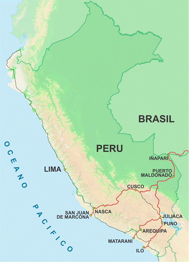
Interoceanic highway
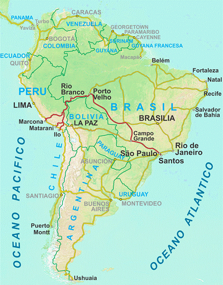
The newly constructed and renovated Trans-oceanic highway (finished in december 2010) connects the Pacific Ocean in Peru with the Atlantic Ocean in Brazil, crossing the Andes and the Amazon jungle from San Juan de Marcona in Peru (near Nasca) to Iñapari on the Brazilian border through Cusco. From the border, you can reach the major cities of Brazil as Sao Paulo, Rio de Janeiro, Brasilia, etc.
Another section runs to the Peruvian port of Matarani through Arequipa and another to the port of Ilo through Puno.
Nasca / Cusco: 660 km (410 mi) - 14 hours
Lima / Cusco: 1,110 km (690 mi) - 20 hours
Cerro Blanco
Ubicated 10 km (6 mi) from Nasca, the "White Mountain" is the highest sand dune in the world that culminates at 2,078 m (6,816 ft) m.a.s.l., with a thickness of sand more than 1,000 meters (3,300 ft), 8 km (5 mi) long and 4 km (2.5 mi) wide. This top gives a spectacular view of the Andes and the Nazca lines. It is the perfect setting to go sandboarding.
The dune is clearly visible from the city.
Pampa Galeras
The biggest vicuñas reserve of the Andes is located 2 hours from Nasca with 40,000 animals (the third part of Peru) in 6,500 ha. The 68 communities living in the region are responsible for their protection.
Abancay
City of nearly 100,000 inhabitants at 2,377 meters (7,797 ft) a.s.l., Abancay is the capital of the department of Apurimac, located in an Andean valley with a very mild climate and beautiful scenery, 470 km (292 mi) from Nasca (10 hours) and 190 km (118 mi) from Cusco (4 hours).
For several years, major mining companies (gold, silver and copper) settled in the area, which boost the local economy.
Saywite
Located 45 km (28 mi) of the city of Abancay and 3,500 meters (11,480 ft) a.s.l., Saywite was an Inca ceremonial center where we can see stairs, fountains, temples and the intihuatana clock (meaning "the place where the sun is tied up" en quechua), typical of all religious centers of this period.
The main attraction is a mysterious monolith, a granite block of four meters (13 ft) in diameter and 2.30 m (7.5 ft) tall with more than 200 animal figures and geometric shapes carved in high relief, that look like a map of the region with terraces, corridors and buildings.
Several theories attempt to explain the meaning of this drawings: a kind of plan to take control of hydraulic works, a sacrifice table where Inca priests studying the flow of blood through the corridors of the plan or an altar dedicated to the worship of water.
Choquequirao
43 km (27 mi) and 45 minutes from Abancay (150 km - 93 mi - 3 h 30 from Cusco), a detour leads to the village of Cachora. From here start the trek to Choquequirao ("cradle of gold" in Quechua), considered the second Machu Picchu, at 3,033 m (9,948 ft) a.s.l., reached by a two-day hike.
Little known because of the difficulty of access and recently restored, is larger than Machu Picchu, with impressive constructions and also located in a beautiful landscape.
From Choquequirao it is possible to continue hiking to other Inca sites like Vilcabamba, Vitcos and Machu Picchu in 7 days.
Limatambo
In this village located 116 km (72 mi) 2 hours 45 Abancay and 75 km (47 mi) -1h 15 of Cusco, is an Inca ceremonial center, Tarawasi.
The temple of this archaeological site is composed of two terraces and three beautiful walls.
Tourism